The remit of the Service Topographie et géomatique (Surveying and Geomatics Department) covers several areas, including:
- measurement work within the city limits as part of various development, architectural, infrastructure, and environmental projects;
- upkeep and extension of geodetic control networks;
- management and updating of various topographic databases whose scale and level of detail is appropriate for municipal needs;
- providing access to extracts from various topographic databases upon internal or external request;
- drafting of thematic maps within the scope of specific publications;
- maintaining working relations with the other municipal departments, other administrations, design firms, architectural and urban planning offices, IT firms, within the framework of municipal and private projects, impact studies, geographic inventories, etc.,
- preparation of official measurements for land surveys and development plans in the public and private domain of the City of Luxembourg;
- representing the City in property transactions and property line disputes;
- checking that the siting of new constructions complies with the building regulations and permits;
- management of numbering plans and of the register of official geo-referenced addresses in Luxembourg City;
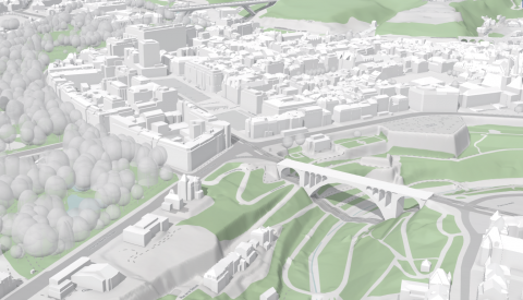
- systematic three-dimensional modelling of buildings to recreate the urban landscape of Luxembourg City;
- coordination and management of the municipal geographic information system in collaboration with the various municipal departments;
- design and management of the "urban information system" www.topographie.lu for the dissemination of public geographic information.
- centralised services for printing, scanning, and all forms of reproduction, digital printing, and photography.